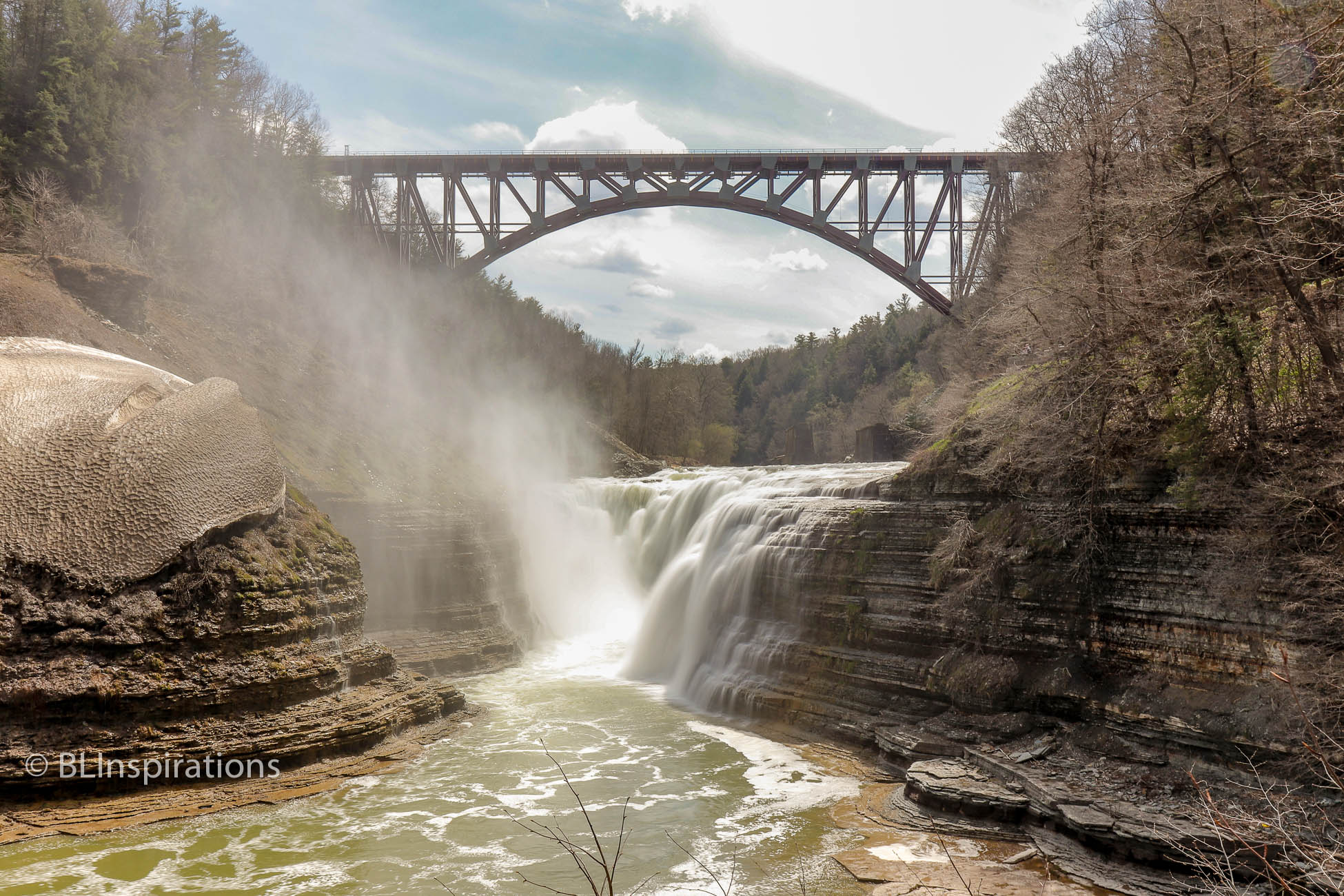
The Upper Falls of the Genesee River in Letchworth State Park is framed by a railroad bridge just upstream of the falls (more about the bridge below). (Please see Letchworth State Park for an overview of the park.) The Upper Falls is J-shaped, 70 feet high, roughly 300 feet wide, and faces east to northeast. A substantial portion of the falls is nearly vertical. There is a walkway along the western side of the falls that provides good viewing areas, including a higher one that overlooks the falls and the gorge just downstream of the falls where a rainbow is frequently visible. While I was at this upper viewing area, another visitor pointed out the location of a bald eagle nest in an evergreen tree upstream. Although not visible with the naked eye, I could just make it out with my telephoto lens and that photo is included in the photo album below.
In several of the pictures in the photo album below, there is a dirty white area on the edge of the gorge, which is an ice cap from frozen spray during the winter. We couldn’t tell how thick it was but it looked to be more than a foot thick and there were constant streams of water running down from underneath it as it melted.
Less than 500 feet upstream of the Upper Falls is a steel arch railroad bridge, which is the third railroad bridge at this location. The original bridge was a timber structure built in 1852, which was destroyed by fire in 1875. At the time, it was the longest and tallest wooden bridge in the world. The railroad immediately replaced that bridge with one built of iron and steel. The second bridge was used until December 2017. The current bridge is 723 feet wide and 235 feet high with a 483 foot arch. (I have not seen the previous bridge but from photos I have seen, the steel arch bridge is much more attractive in this setting than the previous iron and steel bridge.)
More Information
Photo of Upper Falls with old bridge.
Additional Photos


Technical Data
Letchworth Upper Falls 3
- Date: 5/5/2018
- Time: 2:50 PM
- Camera: Canon EOS 77D
- Lens: Canon EF-S 17-55 mm, f/2.8 IS USM
- Filter: 1.5 (5-stop) neutral density
- Settings:
- Lens: 20 mm, f/13
- ISO: 100
- Shutter: 0.4 sec
- Cropped image is 5891 px x 3927 px
- GPS: 42°34’47.735″ N, 78°2’50.67″ W
Letchworth Upper Falls 1
- Date: 5/5/2018
- Time: 2:46 PM
- Camera: Canon EOS 77D
- Lens: Canon EF-S 17-55 mm, f/2.8 IS USM
- Settings:
- Lens: 20 mm, f/8
- ISO: 100
- Shutter: 1/200 sec
- Uncropped image is 6000 px x 4000 px
- GPS: 42°34’49.355″ N, 78°2’52.073″ W
Letchworth Upper Falls Ice Cap
- Date: 5/5/2018
- Time: 3:06 PM
- Camera: Canon EOS 77D
- Lens: Canon EF-S 17-55 mm, f/2.8 IS USM
- Settings:
- Lens: 20 mm, f/8
- ISO: 100
- Shutter: 1/200 sec
- Cropped image is 5891 px x 3927 px
- GPS: 42°34’49.355″ N, 78°2’52.073″ W
Letchworth Upper Falls 2
- Date: 5/5/2018
- Time: 2:46 PM
- Camera: Canon EOS 77D
- Lens: Canon EF-S 17-55 mm, f/2.8 IS USM
- Settings:
- Lens: 20 mm, f/10
- ISO: 100
- Shutter: 1/200 sec
- Cropped image is 5970 px x 3980 px
- GPS: 42°34’49.355″ N, 78°2’52.073″ W
Letchworth Upper Falls 4
- Date: 5/5/2018
- Time: 3:07 PM
- Camera: Canon EOS 77D
- Lens: Canon EF-S 17-55 mm, f/2.8 IS USM
- Settings:
- Lens: 17 mm, f/16
- ISO: 400
- Shutter: 1/320 sec
- Cropped image is 5970 px x 3980 px
- GPS: 42°34’45.011″ N, 78°2’55.781″ W
Letchworth Upper Falls Rainbow & Ice Cap
- Date: 5/5/2018
- Time: 3:05 PM
- Camera: Canon EOS 77D
- Lens: Canon EF-S 17-55 mm, f/2.8 IS USM
- Settings:
- Lens: 17 mm, f/11
- ISO: 400
- Shutter: 1/320 sec
- Uncropped image is 6000 px x 4000 px
- GPS: 42°34’44.946″ N, 78°2’55.614″ W
Bald Eagle at Letchworth Park Upper Falls
- Date: 5/5/2018
- Time: 3:01 PM
- Camera: Canon EOS 77D
- Lens: Canon EF-S 55-250 mm, f/4-5.6 IS STM
- Settings:
- Lens: 218 mm, f/9
- ISO: 800
- Shutter: 1/250 sec
- Cropped image is 1560 px x 2340 px
- GPS: 42°34’47.652″ N, 78°2’52.925″ W