By Laurie
Note: This post is one of a series about my 2015 Western Parks vacation with my daughter and grandson. For our itinerary with links to other posts and an overview of this trip, please see 2015 Western Parks Vacation.
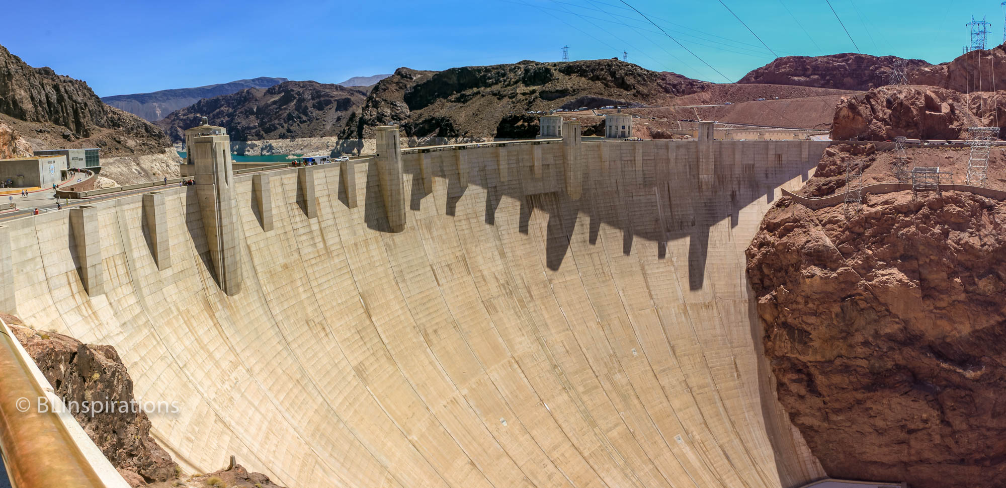
As we drove from Las Vegas to the Grand Canyon, we stopped at Hoover Dam to take photographs, see the visitor center, and have a tour of the dam.
Hoover Dam was built in the 1930s to control floods, provide irrigation water and produce hydroelectric power to the nearby states and Mexico. More recently, Lake Mead has become a recreational area. Originally, US Rt. 93 crossed the crest of the dam, but the road was dangerous because of sharp hairpin turns and was inadequate for projected traffic volumes so a more direct route with a bridge over Black Canyon was proposed. Construction of the Mike O’Callaghan–Pat Tillman Memorial Bridge was started in 2003 and completed in 2010.
There are hydroelectric turbines and generators in powerhouses on each side of the river at the base of the dam. There are roads from the top of the dam to the base to provide access to the powerhouses and other facilities but they go through tunnels and cannot be used for large loads. There is a 150 ton cableway crane which stretches 1200 feet across the canyon used to lift large loads from the base of the dam to the Nevada side.
The high voltage cables from the generators run nearly vertical from the powerhouses to the transmission towers at the top of the canyon. It’s strange to see high voltage transmission towers mounted at a steep angle where the cables transition from nearly vertical to nearly horizontal.
I won’t go into details about the construction of the dam but will provide some links in the Additional Information section below. Here are a few facts about Hoover Dam:
Location: In Black Canyon on the Colorado River, about 30 miles southeast of Las Vegas, Nevada along US Rt. 93. The center of the Colorado River is the border between Nevada and Arizona.
Construction Time: 1931 to 1936 (2 years ahead of schedule).
Dimensions: 726 feet high, 660 feet thick at base, 44 feet thick at crest, 1,244 feet long at crest.
Concrete: 3.25 million cubic yards of concrete for the dam itself, plus 1.11 million cubic yards for the power plant and additional facilities. This concrete would be enough to build a 4000 mile long 2-lane highway.
The dam created Lake Mead with a surface area of 247 sq. miles, maximum depth of 590 feet, and a maximum length of 112 miles. Contracts and treaties allocate specific amounts of Colorado River water to Arizona, California, Colorado, Mexico, Nevada, New Mexico, Utah, and Wyoming. In drought years, the water inflow does not meet the outflow requirements so Lake Mead is drawn down to meet the requirements. When we were there, the water level was down 154 feet from the “full” level and there was a white mineral deposit all around the lake from when the lake was full. That deposit is known as the “bathtub ring.”
Additional Information
Hoover Dam – Wikipedia
Hoover Dam Map (USBR)
The Colorado River and Hoover Dam: Facts and Figures
150 Ton Cableway Crane (PDF magazine article)
Hoover Dam High Scaler Monument
Lake Mead – Wikipedia
Lake Mead Water Level
Additional Images


Technical Information
Hoover Dam Panorama
- Date: 6/22/2015
- Time: 11:14 AM
- Camera: Canon EOS Rebel T1i
- Lens: Canon EF-S 18-55 mm, f/3.5-5.6 IS
- Settings:
- Lens: 18 mm, f/10
- ISO: 100
- Shutter: 1/100 sec
- Cropped image is 8245 x 3997 px
- GPS: 36°0’57.7″ N 114°44’21.4″ W
Hoover Dam and Black Canyon Panorama
- Date: 6/22/2015
- Time: 11:29 AM
- Camera: Canon EOS Rebel T1i
- Lens: Canon EF-S 18-55 mm, f/3.5-5.6 IS
- Settings:
- Lens: 18 mm, f/14
- ISO: 400
- Shutter: 1/160 sec
- Cropped image is 5836 x 5163 px
- GPS: 36°0’59.299″ N, 114°44’16.199″ W
Hoover Dam Transmission Towers 1
- Date: 6/22/2015
- Time: 10:18 AM
- Camera: Canon EOS Rebel T1i
- Lens: Canon EF-S 18-55 mm, f/3.5-5.6 IS
- Settings:
- Lens: 18 mm, f/11
- ISO: 100
- Shutter: 1/125 sec
- Uncropped image is 4752 x 3168 px
- GPS: 36°0’56.099″ N, 114°44’28.2″ W
Hoover Dam Transmission Towers 2
- Date: 6/22/2015
- Time: 11:31 AM
- Camera: Canon EOS Rebel T1i
- Lens: Canon EF-S 18-55 mm, f/3.5-5.6 IS
- Settings:
- Lens: 18 mm, f/13
- ISO: 100
- Shutter: 1/160 sec
- Uncropped image is 4752 x 3168 px
- GPS: 36°0’56.099″ N, 114°44’28.2″ W
Arizona Intake Tower
- Date: 6/22/2015
- Time: 11:31 AM
- Camera: Canon EOS Rebel T1i
- Lens: Canon EF-S 18-55 mm, f/3.5-5.6 IS
- Settings:
- Lens: 18 mm, f/5.6
- ISO: 100
- Shutter: 1/400 sec
- Cropped image is 3135 x 4703 px
- GPS: 36°1’0.199″ N, 114°44’16.3″ W
Lake Mead “Bathtub Ring”
- Date: 6/22/2015
- Time: 11:33 AM
- Camera: Canon EOS Rebel T1i
- Lens: Canon EF-S 18-55 mm, f/3.5-5.6 IS
- Settings:
- Lens: 18 mm, f/11
- ISO: 100
- Shutter: 1/125 sec
- Uncropped image is 4752 x 3168 px
- GPS: 36°0’58.499″ N, 114°44’13.9″ W
High Scaler Monument
- Date: 6/22/2015
- Time: 11:43 AM
- Camera: Canon EOS Rebel T1i
- Lens: Canon EF-S 18-55 mm, f/3.5-5.6 IS
- Settings:
- Lens: 32 mm, f/11
- ISO: 100
- Shutter: 1/125 sec
- Uncropped image is 3168 x 4752 px
- GPS: 36°0’55.8″ N, 114°44’27.4″ W
150 Ton Cableway Crane 2
- Date: 6/22/2015
- Time: 11:50 AM
- Camera: Canon EOS Rebel T1i
- Lens: Canon EF-S 18-55 mm, f/3.5-5.6 IS
- Settings:
- Lens: 34 mm, f/11
- ISO: 100
- Shutter: 1/200 sec
- Uncropped image is 4752 x 3168 px
- GPS: 36°0’56.099″ N, 114°44’28.3″ W