In May 2018, we visited Kinzua Bridge State Park in Pennsylvania to see the bridge and take photos. The Kinzua Bridge (or Kinzua Viaduct) was a railroad trestle that spanned Kinzua Creek valley (or gorge) in McKean County, PA. The bridge was 301 feet tall and 2,052 feet long. Much of its structure collapsed during a tornado in 2003.
Before its collapse, the Kinzua Bridge was ranked as the fourth-tallest railway bridge in the United States. It was listed on the National Register of Historic Places in 1977 and as a National Historic Civil Engineering Landmark in 1982. Kinzua Bridge State Park is located off U.S. Route 6 near the borough of Mount Jewett, PA.
History of the Bridge
The Kinzua Viaduct was constructed in 1882 to transport local coal, oil and lumber across the Kinzua Gorge to their markets.
The bridge, originally built from wrought iron, was 301 feet high and 2,053 feet long. It was billed as the “Eighth Wonder of the World”, holding the record as the tallest railroad bridge in the world for two years. In 1900, the wrought iron bridge was dismantled and simultaneously rebuilt out of steel to allow it to accommodate heavier trains. It stayed in commercial service until 1959 and was sold to the Government of Pennsylvania in 1963, becoming the centerpiece of Kinzua Bridge State Park.
Destruction of the Bridge
In 2002, examination of the bridge revealed that some bridge anchor bolts were corroded. Engineers determined that during high winds, the bridge’s center of gravity could shift, putting weight onto only one side of the bridge and causing it to fail. It was closed to all “recreational pedestrian and railroad usage” and restoration of the bridge began that year. A bridge construction and repair company started work on restoring the Kinzua Bridge in February 2003. On July 21, 2003, an F-1 tornado struck the Kinzua Bridge, snapping and uprooting nearby trees, as well as causing 11 of the 20 bridge towers to collapse. Construction workers had already packed up and were starting to leave for the day when the storm came.
When the tornado touched down, the winds had increased to at least 94 miles per hour and were coming from the east, perpendicular to the bridge, which ran north–south. An investigation determined that Towers 10 and 11 had collapsed first, in a westerly direction. Meanwhile, Towers 12 through 14 had actually been picked up off of their foundations, moved slightly to the northwest and set back down intact and upright, held together by only the railroad tracks on the bridge. Next, towers four through nine collapsed to the west, twisting clockwise, as the tornado started to move northward. As it moved north, inflow winds came in from the south and caused Towers 12, 13, and 14 to finally collapse towards the north, twisting counterclockwise.
The failures were caused by the badly corroded bolts holding the bases of the towers to the concrete anchor blocks embedded into the ground. An investigation determined that the tornado applied a large lateral force against the bridge. The investigation also hypothesized that the whole structure oscillated laterally four to five times before fatigue started to cause the base bolts to fail. The towers fell intact in sections and suffered damage upon impact with the ground. The century-old bridge was destroyed in less than 30 seconds.
For the full story of the bolt failure you should visit the visitor center.
Kinzua Bridge State Park Updated
The state decided not to rebuild the Kinzua Bridge. Instead, it was proposed that the ruins be used as a visitor attraction to show the power of the forces of nature. Kinzua Bridge State Park had attracted 215,000 visitors annually before the bridge collapsed. The viaduct and its collapse were featured in the History Channel’s ‘Life After People’ as an example of how corrosion and high winds would eventually lead to the collapse of any steel structure. The bridge was removed from the National Register of Historic Places in 2004.
In 2005, the Pennsylvania Department of Conservation and Natural Resources (DCNR) released a proposal for a new observation deck and visitors’ center, with access to the bridge and with a hiking trail below, giving views of the fallen towers. The remaining towers were restored and the sky walk was constructed and opened in 2011. The Sky Walk consists of a pedestrian walkway over the remaining towers of the southern portion of the bridge to an observation deck with a glass floor at the end of the bridge that allows views of the bridge and the valley directly below.
The Visitor Center, also located at the southern end of the bridge, opened in 2016. In addition to classrooms and a gift shop, it features interpretive programming and interactive displays on the original need for the bridge to enable rail transportation of local coal, oil and lumber, the original wrought iron construction, the steel rebuilding, as well as information about engineering, energy and the environment. In our opinion, the interactive displays are among the best we have ever seen and well worth seeing, and it’s all FREE!.
More Information
PA DCNR – Kinzua Bridge State Park
Allegheny National Forest Visitors Bureau – Kinzua Bridge State Park
Keystone Edge – Kinzua Bridge State Park Visitor Center
More Photos
In the photo ‘Kinzua Bridge 3’ below, we didn’t see the steel rails still connected between the railroad ties on the ground and the remaining towers on the far side of the valley until we examined the photos. At some point we plan to return to the park and take more photos.


Technical Data
Kinzua Bridge 1
- Date: 5/7/2018
- Time: 2:02 PM
- Camera: Canon EOS 77D
- Lens: Canon EF-S 17 -55 mm, f/2.8 IS USM
- Settings:
- Lens: 55 mm, f/11
- ISO: 200
- Shutter: 1/100 sec
- Uncropped image is 6000 px x 4000 px
Kinzua Bridge 2
- Date: 5/7/2018
- Time: 2:39 PM
- Camera: Canon EOS 77D
- Lens: Canon EF-S 17 -55 mm, f/2.8 IS USM
- Settings:
- Lens: 17 mm, f/11
- ISO: 200
- Shutter: 1/100 sec
- Cropped image is 5629 px x 3753 px
- GPS: 41°45’37.133″ N, 78°35’12.366″ W
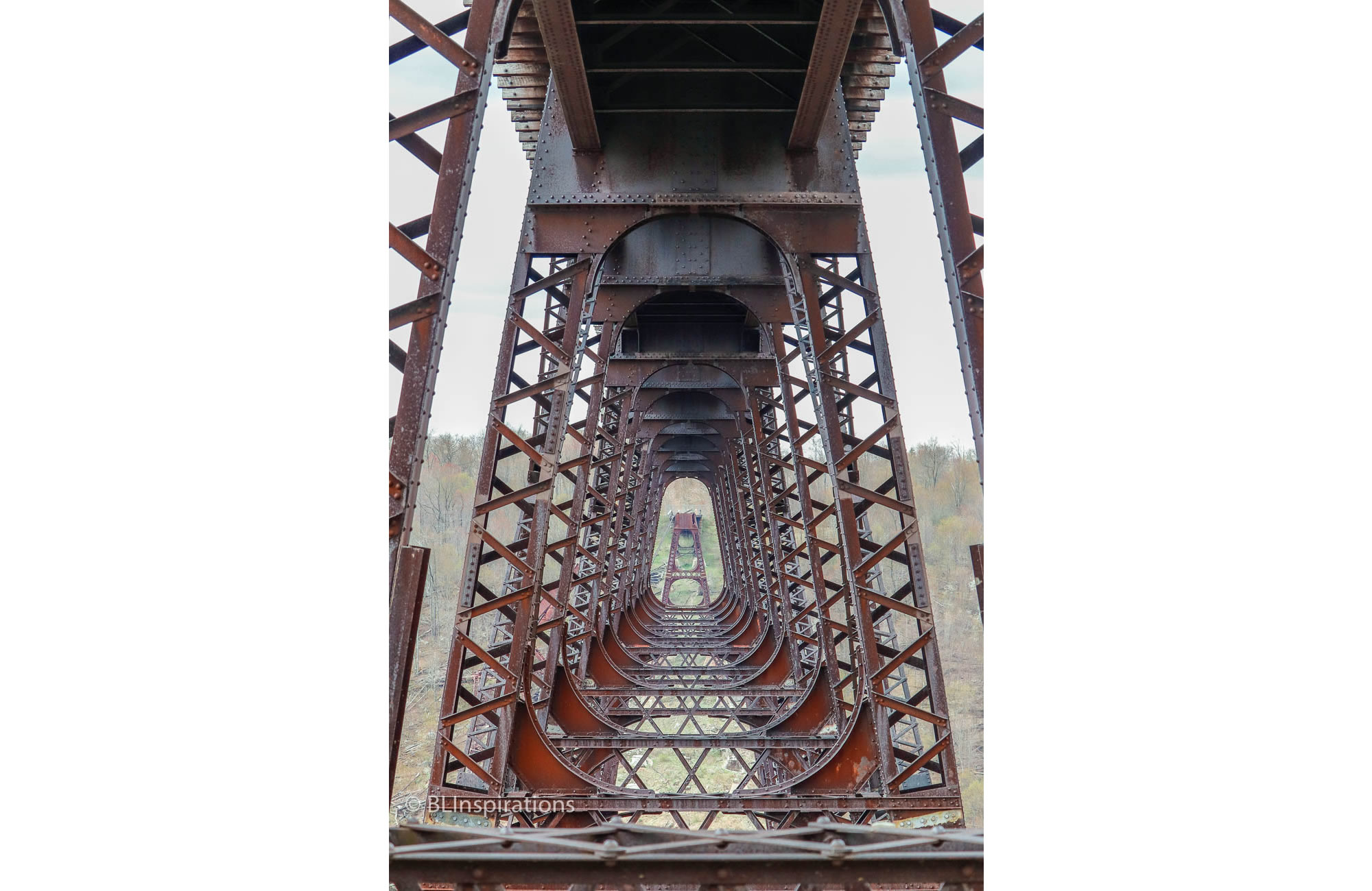
Kinzua Bridge 3
- Date: 5/7/2018
- Time: 2:52 PM
- Camera: Canon EOS 77D
- Lens: Canon EF-S 55-250 mm, f/4-5.6 IS STM
- Settings:
- Lens: 155 mm, f/5.6
- ISO: 200
- Shutter: 1/400 sec
- Cropped image is 3496 px x 5244 px
- GPS: 41°45’37.05″ N, 78°35’13.799″ W
Kinzua Bridge 4
- Date: 5/7/2018
- Time: 2:53 PM
- Camera: Canon EOS 77D
- Lens: Canon EF-S 55-250 mm, f/4-5.6 IS STM
- Settings:
- Lens: 55 mm, f/5.6
- ISO: 200
- Shutter: 1/400 sec
- Cropped image is 3113 px x 4669 px
- GPS: 41°45’37.05″ N, 78°35’13.799″ W
Kinzua Bridge 5
- Date: 5/7/2018
- Time: 2:57 PM
- Camera: Canon EOS 77D
- Lens: Canon EF-S 17 -55 mm, f/2.8 IS USM
- Settings:
- Lens: 21 mm, f/8
- ISO: 400
- Shutter: 1/400 sec
- Cropped image is 5448 px x 3632 px
- GPS: 41°45’37.05″ N, 78°35’13.799″ W
Kinzua Bridge 6
- Date: 5/7/2018
- Time: 2:58 PM
- Camera: Canon EOS 77D
- Lens: Canon EF-S 17 -55 mm, f/2.8 IS USM
- Settings:
- Lens: 23 mm, f/9
- ISO: 400
- Shutter: 1/400 sec
- Cropped image is 3727 px x 5590 px
- GPS: 41°45’36.006″ N, 78°35’17.31″ W
Kinzua Bridge 7
- Date: 5/7/2018
- Time: 3:11 PM
- Camera: Canon EOS 77D
- Lens: Canon EF-S 17 -55 mm, f/2.8 IS USM
- Settings:
- Lens: 17 mm, f/8
- ISO: 400
- Shutter: 1/400 sec
- Uncropped image is 6000 px x 4000 px
- GPS: 41°45’41.387″ N, 78°35’18.492″ W
Kinzua Bridge 8
- Date: 5/7/2018
- Time: 3:11 PM
- Camera: Canon EOS 77D
- Lens: Canon EF-S 17 -55 mm, f/2.8 IS USM
- Settings:
- Lens: 21 mm, f/8
- ISO: 400
- Shutter: 1/400 sec
- Cropped image is 3113 px x 4669 px
- GPS: 41°45’41.387″ N, 78°35’18.492″ W
Biplane over Kinzua Bridge
- Date: 5/7/2018
- Time: 3:23 PM
- Camera: Canon EOS 77D
- Lens: Canon EF-S 55-250 mm, f/4-5.6 IS STM
- Settings:
- Lens: 255 mm, f/13
- ISO: 400
- Shutter: 1/400 sec
- Cropped image is 4731 px x 3154 px