Last October we made a day trip to the Canaan Valley area of West Virginia to see several waterfalls and the autumn colors. This topic has been covered in two posts. This is the second post which features Douglas Falls and Albert Falls (still in Blackwater Falls State Park near Thomas, WV), and a vista viewed from a pull-off along US 48 (Corridor H) at the Allegheny Front. Please see Waterfalls and Autumn Colors – West Virginia – Part 1 for the first post.
After Lindy Point, our next stop was the Blackwater Canyon Trail along the North Branch of the Blackwater River near Thomas, WV. The Blackwater Canyon Trail was formerly a railroad line between Thomas, WV and Hendricks, WV. A railroad through the canyon was built out of necessity, since there was no other practical means of moving freight (primarily coal and lumber) through the rugged Appalachian mountains between the North Branch of the Potomac River and what would become Elkins, West Virginia.
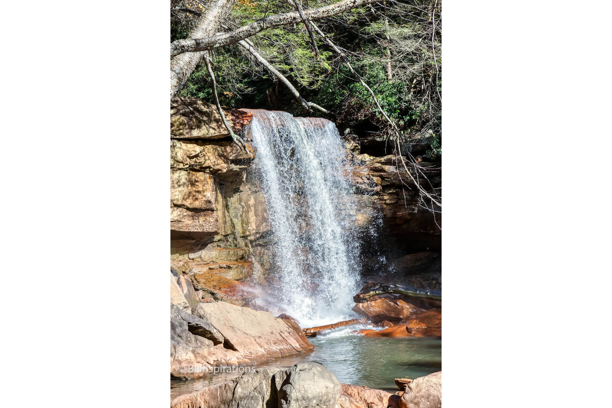
Albert Falls and Douglas Falls are about 0.4 miles apart, near the upper (Thomas) end of the trail. Albert Falls is only several feet high but at about 35′ high, Douglas Falls is much more impressive. There are additional waterfalls farther down the trail but we didn’t go any further.
The access to the area near the base of Douglas Falls where the featured photo was taken is steep and rocky. Fortunately some kind person left a rope to assist in the descent and ascent. After making the descent and taking some photos near the base of the falls, I wanted to take more photos from farther downstream to show the colorful rocks in the river. There was a clump of trees that had been undercut and partially fallen into the river bed (shown in the Additional Images section below) that I was able to maneuver around. I took the featured photo from there but was not able to return with the use of one hand, since I had to carry my camera1. Below the falls and the downed trees, the embankment of the canyon was steep with a lot of loose footing and little vegetation to use for handholds and I was unable to climb up directly. I was able to make slow progress by going diagonally up the bank, kicking footholds in the loose soil, and occasionally grasping a small branch to help, only to slide down to the brush at the retaining wall along the river’s edge. On my second attempt, at a different location, I was able to throw my camera up to Beverly who was along the edge of the trail so I could use both hands. Then Beverly was able to find a branch that she held down to me to help me complete the ascent. It probably took 1/2 hour to climb the embankment. Later, Beverly said that when I slid down the embankment, she was afraid I was going to die, and once I made it safely up, she was ready to kill me for having done such a stupid and dangerous thing.
There are remnants of former railroad and coal structures with interpretative signage along the Blackwater Canyon Trail above Albert Falls near Thomas and there is a photo of several old coke ovens in the Additional Images section below. Coke was used in the steel-making process and was made by carbonizing coal (heating coal in an oxygen-free atmosphere).
On our trip home we stopped at a pull-off along US 48 (Corridor H) at the Allegheny Front, a few miles SE of Mt Storm near Keyser, WV. There is a tremendous view from this pull-off and there are hundreds of wind turbines on both sides of the highway in that area. There are several photos taken from this pull-off in the Additional Images section below. The panorama was made from 24 separate images – eight HDR images each made from three separate images.
The featured image and the images in the Additional Images section below are all HDR images made from three identical images taken at different exposures. (For an explanation of these techniques, please see the Definitions page.)
1 I have a Cotton Carrier Camera Harness that allows the user to securely carry a camera and a long lens ‘hands free’ but I hadn’t thought to bring it on this trip. I originally used the harness when horseback riding – see the post Ultimate Train & Trail Ride.
Additional Information
Blackwater Canyon Trail: TrailLink
Blackwater Canyon Trail History: TrailLink
Douglas Falls: West Virginia Waterfalls (also mentions Albert Falls), Emerald Waterfall
Additional Images


Technical Information
Note: I neglected to start my GPS trip g during this segment so the GPS locations are approximate, taken from Google Maps.
Albert Falls
- Date: 10/21/2019
- Time: 3:10 PM
- Camera: Canon EOS 77D
- Lens: Canon EF-S 17-55 mm f/2.8 IS USM
- Settings:
- Lens: 31 mm, f/11
- ISO: 400
- Shutter: 1/125 sec
- Uncropped image is 5926 x 3949 px
- GPS: 39°7’42.6″N, 79°31’13.9″W
Douglas Falls
- Date: 10/21/2019
- Time: 3:27 PM
- Camera: Canon EOS 77D
- Lens: Canon EF-S 17-55 mm f/2.8 IS USM
- Settings:
- Lens: 44 mm, f/11
- ISO: 400
- Shutter: 1/750 sec
- Uncropped image is 3959 x 5955 px
- GPS: 39°7’25.8″ N, 79°31’11.4″ W
Uprooted Trees
- Date: 10/21/2019
- Time: 3:26 PM
- Camera: Canon EOS 77D
- Lens: Canon EF-S 17-55 mm f/2.8 IS USM
- Settings:
- Lens: 17 mm, f/11
- ISO: 400
- Shutter: 1/90 sec
- Uncropped image is 5953 x 3950 px
- GPS: 39°7’25.8″ N, 79°31’11.4″ W
Douglas Falls and Rocks
- Date: 10/21/2019
- Time: 3:30 PM
- Camera: Canon EOS 77D
- Lens: Canon EF-S 17-55 mm f/2.8 IS USM
- Settings:
- Lens: 38 mm, f/11
- ISO: 400
- Shutter: 1/250 sec
- Uncropped image is 3977 x 5953 px
- GPS: 39°7’25.7″ N, 79°31’11.5″ W
Coke Ovens
- Date: 10/21/2019
- Time: 4:14 PM
- Camera: Canon EOS 77D
- Lens: Canon EF-S 17-55 mm f/2.8 IS USM
- Settings:
- Lens: 17 mm, f/13
- ISO: 400
- Shutter: 1/45 sec
- Uncropped image is 5953 x 3936 px
View southeast from pull-off
- Date: 10/21/2019
- Time: 4:47 PM
- Camera: Canon EOS 77D
- Lens: Canon EF-S 17-55 mm f/2.8 IS USM
- Settings:
- Lens: 48 mm, f/13
- ISO: 400
- Shutter: 1/750 sec
- Uncropped image is 5970 x 3967 px
- GPS: 39°13’15.45″ N, 79°11’30.81″ W
Allegheny Front Panorama
- Date: 10/21/2019
- Time: 4:47 PM
- Camera: Canon EOS 77D
- Lens: Canon EF-S 17-55 mm f/2.8 IS USM
- Settings:
- Lens: 42 mm, f/13
- ISO: 400
- Shutter: 1/250 sec
- Cropped image is 19687 x 5372 px
- GPS: 39°13’15.45″ N, 79°11’30.809″ W
Wind turbines along Allegheny Front
- Date: 10/21/2019
- Time: 4:48 PM
- Camera: Canon EOS 77D
- Lens: Canon EF-S 17-55 mm f/2.8 IS USM
- Settings:
- Lens: 55 mm, f/13
- ISO: 400
- Shutter: 1/1000 sec
- Uncropped image is 5911 x 3924 px
- GPS: 39°13’15.45″ N, 79°11’30.81″ W